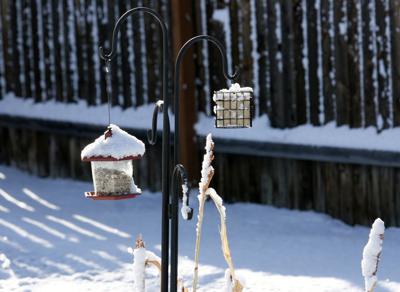
Hail and snow that hit Challis on March 25 covers these bird feeders. Warmer temperatures a few days earlier had brought plenty of chirping birds in to feed, but they scattered until the snow cleared.
Hail and snow that hit Challis on March 25 covers these bird feeders. Warmer temperatures a few days earlier had brought plenty of chirping birds in to feed, but they scattered until the snow cleared.
Data collected in the April 1 snow survey showed tremendous discrepancies in Idaho’s mountain snowpack conditions, according to the most recent report from the Natural Resources Conservation Service.
The trend of low snowpack, and the resulting low streamflow forecasts, in northern Idaho versus high snowpack and expected high streamflow in southern Idaho continues this spring, the report shows. Northern Idaho has one of its lowest snowpacks on record and for the second-straight year, southern Idaho’s snowpack is one of its biggest, the report states.
The report’s authors called March weather “tumultuous. Significant snowfall brought many basins closer to normal snowpack conditions,” but warm weather between snow storms began melting snow early. Southern and eastern Idaho received the most precipitation in March, with much less precipitation in the northern part of the state, the report states.
March temperatures were near normal from the Salmon basin northward and cooler than normal from central to southern Idaho.
Basins along the southern Idaho border range from 118 to 138 percent of normal for total water year precipitation. The Lost, Wood and upper Snake basins range from 91 to 105 percent of normal for the total water year. West-central basis range from 89 to 93 percent of normal. From the Salmon basin to the Canadian border the numbers range from 76 to 92 percent of normal.
However, 47 percent of Idaho lands are still considered abnormally dry or in drought.
Overall water supply for Idaho looks sufficient, according to the report. Reservoir storage is at or above normal, with the exception of Mackay Reservoir, sitting at 79 percent of normal storage, which is 58 percent full. Brownlee and Lake Pend Orielle are both at 76 percent normal storage, also on the low end.
Snowpack caught up to normal in March in the Lost and Wood basins, with precipitation ranging from 110 to 150 percent of normal last month.
That moisture boosted total water year precipitation to between 90 and 105 percent of normal in the two basins. The basins are at 90 to 95 percent normal snow water equivalent.
The Salmon River basin received above normal precipitation in March, registering 109 percent of normal, raising the total water year precipitation to 87 percent of normal. Snowpack is at 77 percent of normal peak snow water equivalent. It’s unlikely the basin snowpack will reach normal this year, the report’s authors wrote.
Streamflow forecasts for the Middle Fork Salmon River and Main Salmon River are pegged at 81 and 86 percent of normal, respectively.
We welcome comments, however there are some guidelines:
Keep it Clean: Please avoid obscene, vulgar, lewd,
racist or sexual language. Don't Threaten:
Threats of harming another person will not be tolerated. Be
Truthful: Don't lie about anyone or anything.
Be Nice: No racism, sexism or any sort of -ism
that is degrading. Be Proactive: Report abusive
posts and don’t engage with trolls. Share with Us:
Tell us your personal accounts and the history behind articles.


(0) comments
Welcome to the discussion.
Log In
We welcome comments, however there are some guidelines:
Keep it Clean: Please avoid obscene, vulgar, lewd, racist or sexual language. Don't Threaten: Threats of harming another person will not be tolerated. Be Truthful: Don't lie about anyone or anything. Be Nice: No racism, sexism or any sort of -ism that is degrading. Be Proactive: Report abusive posts and don’t engage with trolls. Share with Us: Tell us your personal accounts and the history behind articles.